Thursday 30 May 2019

Byrness to Kirk Yetholm (2 days)

I honestly don't know how George completed this leg in one day, I was in bed by 8pm, completely done in!
Though the route from Byrness to the mountain bothy maps out as 29km, Adam's watch gps totalled our day at 31km, and 1200m ascent, there's no way I would have been happy trying to tack on the final 11km to that.
We started out from our campsite around 8:30 on the 29th, following the river to Byrness itself, and then straight up a steep 200m climb into the Cheviots. After this effort the trail winds over the hills, summit after summit but mostly rising and falling only 30-80m. Though my photo climbing the first hill shows clear skies, the weather front raced up behind us, with a vicious wind and sharp drizzle.We bypassed the route that goes past the Roman fort ruins, but could see them quite clearly from the hillside, merely ridges in the grass. From very early we could spot the distant outline of The Cheviot, a long hump of a hill, highest summit of the region at 815m. It was both daunting and encouraging the way it's features slowly came into focus as we progressed towards it.
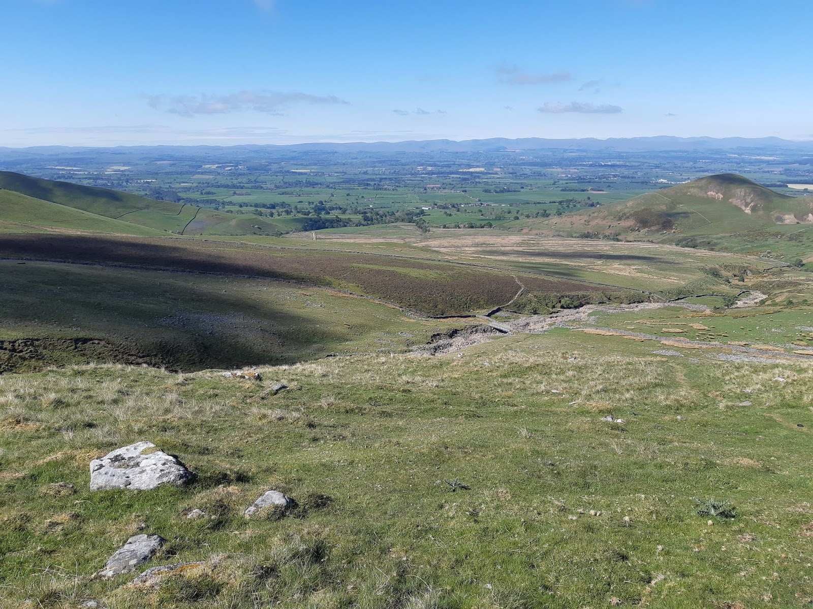
The next major climb is 2 steep sections of trail separated by a smooth but sharp ridge, up to Windy Gyle. Whether it was living up to its name, or if the cold front finally caught us properly, "Windy" proved accurate. As we traversed the steep slope I could feel my bag being tugged sideways, and every breath was snatched away making the air seem thin. It was a pertinent reminder that though this terrain seems tame compared to New Zealand mountains, it can be every bit as treacherous if the weather is against you.
From Windy Gyle the trail drops down to follow a ridge towards the now very apparent Cheviot, followed by yet another steep 200m climb. This took us to a point where desicions had to be made - do we make the 4km round trip to summit The Cheviot? Adam had already been (in January no less!) and I think was hurting pretty bad at this point. No mistake, so was I, but I can't just walk past something like that, it feels incomplete. So we split, Adam to head to the hut, and I to drop my pack and make the steady climb to the trig. We made arrangements for contact times, in case something went wrong, and I finally pulled out my windproof overtrou (I'd walked all day in shorts!), threw on an extra layer, and hungrily downed a porridge bar.
I will be the first to admit that I'm not a runner, but the feeling of being packless, and flying along the pavers, was impossible to resist. I made the summit and back in 40 minutes, part walking part jogging. While that's only a 6km/hr average speed, I'll admit I'm pretty chuffed with that, after already hiking nearly 28km. The final descent to the mountain shelter where we were to stay was an absolute killer. Sheer downhill that made my knees tremble with exhaustion at every step. Arriving at the simple bothy was a total relief - even though it was nothing more than four sturdy walls, a concrete floor, and benches on 3 sides. Blessings upon those who have gone before! Inside we found tea and coffee supplies, including powdered milk, and instantly made ourselves a brew (we had our own tea but the milk was a real bonus). I must remember to return one day with additional supplies for future hikers. Dinner was a simple meal of beans and packet mash potatoes, with extra cheese, and we only had energy for a couple of games of cards crashing into our sleeping bags.
The final day dawned uncertainly, with clouds and wind whipping over our exposed ridgeline. However the route remained fairly easy to follow, as long as we checked the map when farm tracks crossed our path. There is one major hill called the Schill, which we hauled ourselves over, and then it is basically downhill most of the way to Kirk Yetholm, passing old settlements, and then farmhouses, and one last very unwelcome climb over a saddle and down into the village itself. Officially completing the Pennine Way - I cannot express the feeling.
Who should we see as we approach the green, but George! A day ahead of us, and looking all the better for his night in a proper hotel bed, the bastard. It was lovely to catch up with him before he caught his bus onwards, especially as he regaled us with tales of his 48km day, due to taking a wrong path early on.
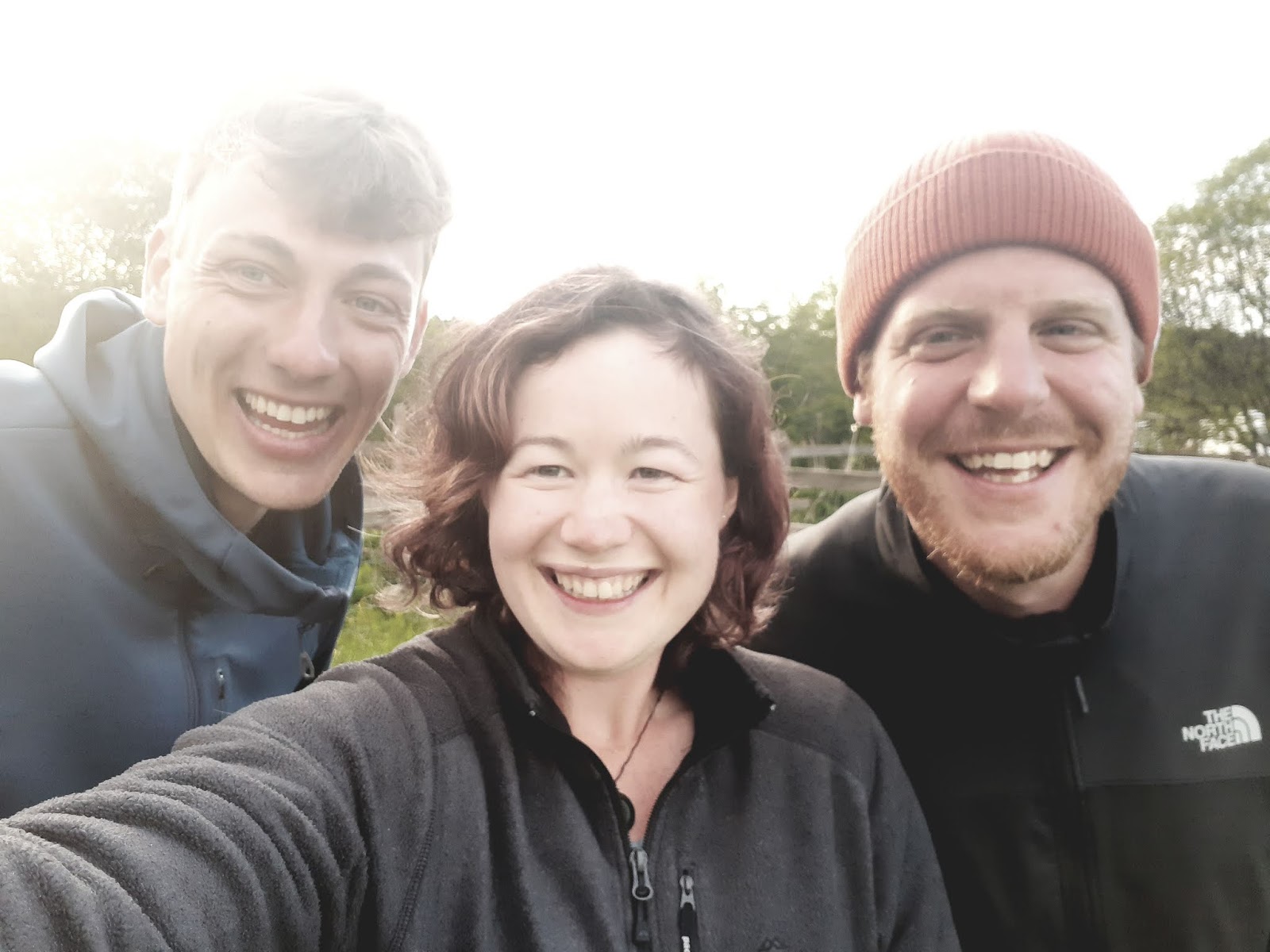
I'm now continuing on my own way from now, Adam got picked up by a friend and hour after George disappeared. I have no words to explain how grateful I am to have met Adam on that first day, atop Kinder Scout. You don't ever expect to just meet someone who you can then walk with for 400km, 17 days, and part as new-found friends.
The Way challenged me, in ways the previous 400km from London did not, and there were times when I definitely needed the support of another person. The Way also awed me in places, and it was nice to be able to turn to someone to share that moment.
I am, without a doubt, unbelievably lucky.

Steeper than it looks

All praises to those who laid the path...

...Even if it's being swallowed by the land in places

Very windy on Windy Gyle

Yellow arrow -  approx. Cheviot summit. Red arrow - approx. bothy location. Taken from summit of Windy Gyle.

Our luxury accomodations

Can't resist playing the ukulele in unlikely locations

A man went on the Pennine Way
To prove that he was tough
But cos he didn't plan ahead
So here he slept it rough!

Good morning!

Next stop: Kirk Yetholm!


Tuesday 28 May 2019

Bellingham to Byrness

The boggiest of bogs!
And we thought the section after Tan Hill was bad.... While it was clear first thing this morning, as we meet up with George for breakfast, it quickly began to drizzle as we started walking, and developed heavier as we hit the hills. This promoted a brief discussion on English terminology for rain, with the consensus that currently it was raining, certainly more than drizzling, but not so far as "pissing down", and definitely not "raining cats and dogs".
The track became less clear over the moors until we hit a section where the path disappeared altogether. Relying on the compass bearing, and gps, we had to strike out across heather and bog, aiming for Whitley Pike. In the end I think it was only a kilometre that we had to fight through, but it seemed much further. Deceptively solid-looking green areas should be avoided, as more than once I plunged my foot ankle-deep in peaty water, through the sphagnum moss.
The route then follows forest roads down to Byrness and our campsite - easy walking after the moorland and steep climb that morning. There is nothing in Byrness, no shop, and the Inn is full so had already told us we couldn't eat there. That being the case we had stocked up in Bellingham, and George, Adam, and I shared a pasta dinner cooked in batches in our little camp stoves.
This is the last we'll see of George on this trip, as he is powering through 42km to get to Kirk Yetholm and the end of the Pennine Way tomorrow. I am less ambitious, so Adam and I are camping in the hills, hopefully in the mountain bothy near Cheviot, and then descending the last 12km the next morning.
I will have to conserve battery until we get to the other side, so unlikely to be a post tomorrow!

Star moss
Path? What path?

This rock made a very comfy seat at the 20km mark


Teamwork makes the dream work!

Monday 27 May 2019

Once Brewed to Bellingham

Today was a good day!
Most importantly, it was Adam's birthday, and his football team had a finals match on at 3pm - which of course necessitated getting to Bellingham in time for kick-off.
We aimed to leave the hostel at 7:30, but were held up by a pot of tea, and polite conversation with a group of Americans that I met last night. They were full of concern that I was heading out the door without a jacket on, and asked if I recognised the signs of hypothermia - thanks, I think I'll be fine.
I actually made it a good few kilometres, along the wall, past the famous Sycamore Gap, and north into the Kielder Forest, before the drizzle became persistent enough to require my raincoat - and I can promise you I'm perfectly comfortable in shorts in the rain.
The path wound through the pine forest, with a couple of k's of boogy moorland (MORE moorland) and we lunched hunched in a patch of trees as the rain continued. Singing along to some T-Swift did brighten the dreary day.
Another bonus today was a lovely "pit-stop" set up in someone's farm shed - free tea and coffee, biscuits, and a box of hiker supplies left by other walkers. A note from the owners said that their mother used to do tea and buns for Pennine walkers, but they never found the time to do it when they took over the farm. However after walking the Pacific Crest Trail they were inspired by the kindness given to them to provide something for walkers on their property again - magic!
Striking out across farmland we met Maggie, a friend of Adam, who came up for the afternoon and ran back from Bellingham to meet us at the not-at-all-amusingly-named Shitlington Hall. A brief hike up the Shitlington Crags then takes you on the downward track into Bellingham.
We made it to the pub in time to have some cake and blueberries brought by the lovely Maggie, and meet an unexpected Aston Villa fan for Adam to buddy up with. This guy was full out in his Aston Villa kit, and Aston Villa tattoo proudly on his leg - brilliant.
I'll admit I didn't watch the game closely, chatting with Maggie and then reading my book for a while. However I did see 2 out of the 3 goals scored, and did get involved in watching the tense final 7 minutes, with 2 excellent saves - resulting in a 2-1 victory for Aston Villa over Derby, winning the Championship League, and getting them promoted to Premier League - Adam is a happy boy!
Sycamore Gap


Sunday 26 May 2019

Greenhead to Once Brewed

Today was our "rest day" taking a very slow start, enjoying a leisurely breakfast before walking out into the rain. Luckily we only had a short walk before reaching the Roman Army Museum where we could hide from the weather for a while. With it's bright displays, "holographic" teacher, and 3D film, this museum feels more aimed at kids, but I did pick up an interesting snippet or two.
Emperor Hadrian wanted to consolidate rather than expand his empire, so ordered the Wall built in AD122, to keep back the barbarians to the North. Although some sections were initially built of turf and wood, the whole thing was eventually made in stone - 12 feet high and 8 feet wide, with "mile forts" every Roman mile (1481m) and two watchtower turrets evenly spaced between each fort. The wall was also protected on it's southern side by a deep ditch, with access over gated paths - this kept the locals safely out of the military zone and reduced the possibility of attack from behind.
Though duty on the wall would generally have been fairly isolated, fortresses like Vindolanda provided a hub for bath houses, taverns, trade, and all other requirements for soldiers on RnR.

The walk itself follows the wall as it rises and falls along the steep crags and "gaps". The crags' sharp northern cliffsides providing added height to an already formidable barrier. Sometimes the wall disappears altogether, stone having been reappropriated for other buildings, such as Thirlwall Castle, in the many years since.
Some of the most complete ruins in this section is the fortress of Aesica, built on the site of Mile Fort 43. Here sections of gatehouse jut from the earth, and some central structures are visible as hummocks in the grass. Of particular interest is a stone altar, an image of a jug carved into one side, standing in the centre of a walled square. I have since found remarks that it was placed there around 1928, evidenced by complaints to an archeological journal at that time about the addition. Of course it may be legitimate Roman remains, moved from a less obvious site, but that seems to be unknown. Regardless it has captured the attention of walkers for almost 100 years now, with gifts (offerings?) of coins adorning its surface.
Thirlwall Castle (14th C)


Turret remnants

A natural barrier

Aesica West gatehouses

Well ensconced now, but not its original position


Saturday 25 May 2019

Alston to Greenhead

Another day of slogging through farmland, and slogging through moors. Plus it rained lightly but persuasively all afternoon.
Mild entertainment provided by steam train seen on the South Tyne way (Adam maintains this was VERY exciting - *roll eyes* honestly, boys)


Dufton to Alston

This is the biggest day on the Pennine Way, over 30km and also the ascent over Cross Fell, the highest point on the Way - and an area notorious for poor weather and poor navigation. Only the day before we spoke to an older gentleman who managed to get himself on the wrong side to ascend, and then descending in the wrong direction! In clear weather! We spent the evening obsessing over the maps and route descriptions in the guidebooks, though frankly it looked pretty straightforward.
I don't know what we did to deserve such good luck, but the cloud clinging to Cross Fell cleared as we traversed the 3 fell summits leading up to it, and we greeted the top under blue skies, albeit with a pretty strong wind. As we came down the other side I could see how someone heading south could get onto the wrong route up, but I really don't see how you could then exit the summit in the wrong direction. I guess it's just a lesson in assumptions - check the compass if you're uncertain of your direction.
Then begins a slow descent into Garigill along the Old Corpse Road - where miners bodies used to be carried over the hills to be inhumed in a churchyard. We stopped in Greg's Hut - a basic 2 room shelter, although provided with a small coal fire. Here we chatted to two lovely ladies on the Pennine Journey (a different but sometimes overlapping route), who informed us that the Post Office shop looks closed but is in fact open, and well worth a chat with the proprietors, meanwhile the pub we had looked forward to is closed for change in ownership. The conversation then devolved into a political rant, thoroughly enjoyable, but a little over my head.
The Post Office shop did indeed have provisions for us, and a good old chat with yet another accent, and they were even able to do a pot of tea! We rested, attempting to convince our feet that they could manage the last 6km to Alston, which traversed along another pretty river. Occasionally the bed of the river jutted up to expose the bare rock slab, and provide mini falls, a geological feature I may have been more interested in if I was less sore. Oh well, another time.

Looking back towards Dufton

On the summit of Cross Fell

Greg's Hut

Upthrust rock riverbed

Friday 24 May 2019

Middleton-in-Teesdale to Dufton

It is without a doubt that this is one of the most spectacular days on the Way. The path follows the River Tees, with bluebell woods and sickeningly sweet tableaus of bunnies in fields. The 2 main waterfalls, Low Force and High Force, are both well worth a day walk to visit in themselves.
The route then turns west up another river valley (still technically the Tees), with some difficulty walking, boulder-hopping on the river's edge. Turning a sharp corner you are confronted by the power of Cauldron Snout, the natural outflow of Cow Green reservoir. The bridge is above the falls, and is reached by some more rather precarious climbing.
Finally, after slogging along the ridgeline and passing back across the Maize Beck (now much smaller than where it feeds into the River Tees), and feeling like you've already been astounded enough, you reach High Cup Nick. No photo I've seen does just to this breathtaking glacial valley, and coming from this side means that you appear at it's upper edge without warning, sheer cliffs and buttressed rock overlooking the perfectly smooth curves of the valley. Truly something that must be experienced.


High Force
Below Cauldron Snout
Above Cauldron Snout - not so much a waterfall as a chute

Totally inadequate photos at High Cup Nick:


Wednesday 22 May 2019

Tan Hill Inn to Middleton-in-Teesdale

I almost thought I wouldn't want to write about today at all. Starting off at 7am we tackled miles of unpaved bog and uneven terrain, cranking through 14km before 10am. We did keep ourselves entertained for a while with word games, and a round of "music man" where each and a starting phrase and then added on another instrument and sound effect to the song. I seriously nearly wet myself laughing as we all made horrible imitations of musical instruments, and persistently forgot which order they were in.
Despite the laughter, the morning seriously was a difficult slog through uninspiring landscape. Although it did prove the ability of my new shoes to dry rapidly.
Blackton Reservoir is pretty, with its nature reserve, and we dipped our feet in the chilly water of Grassholme Reservoir. Then it was one last climb over the hill with lovely views (and a convenient honesty box tuck shop at Wythes Hill Farm) and down into Middleton-in-Teesdale.
George had forged on ahead, but we found him immediately when we entered the first tea shop we came across - there he was drinking Yorkshire tea, with milk! Clearly the lesson at Tan Hill struck the right note.
The very last part of our day is most worth mentioning. After dinner Adam and I continued on to a campsite 4km further along the route. This became a quintessential English countryside walk, with bluebell woods and rabbits alert in the fields (seriously, I field I think had over 40, it was a bit weird). With the sun low on the horizon, and no one else in sight it was a perfectly idyllic finish to the day.

7am at Tan Hill


Blackton Reservoir